In 2022, OpenStreetMap US welcomed the return to in-person events with our 10th annual State of the Map US conference. All of the efforts made by the US community to connect virtually during the 800+ days since our last national gathering were clear in the quality of presentations, enthusiasm of attendees, and continued dedication to the OSM project. In addition to the conference, it was a big year for the OpenStreetMap US organization. I continue to be amazed and inspired by the energy and support of this community and look forward to what 2023 will bring. Join me in acknowledging and celebrating some of the highlights of 2022.
With Gratitude,
Maggie Cawley
Executive Director
PROGRAMS & INITIATIVES
OpenStreetMap US has seen its biggest year yet for growth in programs and initiatives to broaden engagement and interest in OSM across the country. Here is a snapshot:
Government Working Group
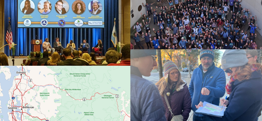
OpenStreetMap US continues to convene federal, state, and local government stakeholders through our monthly Government Working Group meetings. Learn more about what’s driving federal collaboration with OpenStreetMap in this panel at FedGeoDay 2022.

Trails Stewardship Initiative
OpenStreetMap US is convening a diversity of perspectives on trail mapping practices, recreational safety, and conservation to address on-the-ground challenges related to trail navigation and OpenStreetMap data in the United States. Through the Trails Stewardship Initiative, navigation apps using OSM data can more accurately display trail routes to help recreationists make safer, more informed, and environmentally conscious decisions while navigating our public lands. In 2022, the group completed the first mapping pilot in Washington state, engaged 63 stakeholders and is developing plans for a national campaign to improve trails data across the country. Learn more about the initiative from the Nowhere podcast, this State of the Map presentation and the OpenStreetMap US website.
Public Domain Map
Public Domain Map is a new collaborative mapping tool from OpenStreetMap US that allows volunteers to contribute to government datasets and OpenStreetMap simultaneously. Developed in collaboration with federal partners, Public Domain Map is designed to multiply the power and impact of volunteer mappers contributing to the public good by combining crowdsourcing efforts. We’ve made significant progress this past year in the technical development and plan to launch a pilot testing soon with OSM and National Map Corps volunteers. Learn more from presentations at Mapping USA, FedGeoDay 2022 and State of the Map.
TeachOSM
This year was all about collaboration for TeachOSM! With the launch of the OSM US Education Working Group, led by TeachOSM, we were able to bring in the skills and support of more volunteers. We initiated the Collaboration Grants to promote cross-school collaboration around open mapping projects. In addition to these highlights, TeachOSM hired two interns to assist with communications & project outreach, as well as develop new educational content.

Mapping for Impact
We continued to grow the Mapping for Impact program this year with your support! First, we were able to complete playspace and park mapping in Colorado for KABOOM! & the Colorado Health Foundation. This resulted in a ground truthing study by North Carolina State University that highlights the positive impact of crowdsourcing map data. We also launched our ongoing partnership with Rising Tide Effect to map every pool in New York City to help advocate for equity in swim access and safety. This project is 75% complete - help us reach 100% here. After remote mapping pools, we’ll move on to collecting critical attribute information.
12 months of OpenStreetMap
In 2022, we continued the 12 Months of OpenStreetMap initiative to engage the mapping community and volunteers around a new theme every month with projects, blog posts, and themed Mappy Hours. This year we had ~900 OSM changesets contributed to projects with the hashtag #12monthsofOSM! A special shoutout to OSM user wireguy who is the largest contributor to the 12 Months of OSM with over 23,000 edits so far! (Wireguy has also been a rockstar validator for projects on the OSM US Tasking Manager - thank you!)
EVENTS
Thankfully, 2022 saw a return to in-person events. The US OpenStreetMap community has been gathering across the country in addition to regular virtual events.
State of the Map US 2022 in Tucson
In April we headed to the University of Arizona campus in Tucson for the tenth State of the Map US conference. It was especially meaningful to gather in person after 800+ days since the last State of the Map conference. The conference was a great success with over 250 attendees, 22 sponsors, and 75 speakers. All of the talks were recorded and can be found over on our YouTube channel.

Mapping USA + WikiConference North America
In November we joined forces with WikiConference North America to produce a joint virtual conference. The result? Over 300 attendees signed up, close to 60 speakers presented with over 40 talks and presentations, and a combined $1,800 raised for both OpenStreetMap US and WikiConference North America. You can watch the first day’s presentations here.
Local Chapters Congress
The Local Chapters and Communities Congress is an annual, virtual event where leaders and members of various OSM communities, whether they are officially recognized Local Chapters of the OSM Foundation or just a regular user group of OSM mappers, come together to share stories and learn from each other. This year, mappers from around the world gathered on November 12 and held a half day of talks and open conversation. You can learn more here.

Local meetups & community driven initiatives
This year, many local OSM groups - from OSM Seattle to MappingDC - were able to return to in-person meetups for mapathons and mobile mapping parties. OSM Utah explored the use of the new Every Door app by mapping their local mall (documented here in an OSM Diary post and in a Mapping USA talk by Martijn van Exel). MappingDC explored the Southwest Waterfront area in DC to map points of interest. OSM NYC stayed busy from mapping bike racks with BetaNYC & NYDOT for Open Data Week to teaming up with Wikimedia NYC for meetups. Any great meetups that we missed? Email us and we’ll add them here!
Over the past year, we’ve also seen some exciting and innovative community-driven activities that include the evolution of OpenStreetMap Americana, and mapping of the 9/11 National Memorial Trail.

Images, clockwise from upper left: OSM Americana; TeachOSM Mapping Party at State of the Map US; OSM Seattle’s OSM 18th Birthday celebration (credit: Chase Stevens); NYC Bike Rack-a-thon at Open Data Week)
BEHIND THE SCENES
Even if it’s not always visible, the OSM US team is hard at work! Here are just a few of the ways OSM US has grown this year.

Quincy Morgan joined the team
In June, Quincy Morgan came on board as a part-time technical lead. Quincy is working to expand the impact of our organization and programs through improved engineering and technical solutions.
Supporting interns & students
In collaboration with Everywhere She Maps, OSM US hosted two interns last year, Maya Lovo & Hayden MacLachlan, to support communications & outreach for the TeachOSM program. OSM US also supported graduate students from the University of Virginia Data Science Program to explore data completeness of OSM in the US.
Launched Organizational Membership
In 2022 we expanded our membership to companies, educational institutions, nonprofits, and government agencies. Inspired by other organizational models in the OSM ecosystem, we designed the membership to provide an avenue for US organizations to give back to our growing community. Development Seed joined us as our first organizational member. In addition, we created a new Professional level for individuals to create more opportunities for networking in our community.
Launched a new Membership Portal
OSM US has successfully migrated to a new membership management system that enables members to take a more active role. As part of this migration, members can now update contact information, check membership status, and manage renewals!
Thanks for a fantastic 2022! The OSM US team looks forward to accomplishing even more alongside the community in 2023. If you’d like to stay up to date on events, programs and other announcements subscribe to the monthly OpenStreetMap US newsletter! Happy mapping!